GPS, or Global Positioning System, is like a digital map for your drone. It relies on a network of satellites orbiting the Earth to help your drone pinpoint its exact location anywhere on the planet. These satellites send signals to your drone, which then uses them to figure out where it is.
What Does GPS Do In A Drone?
GPS is like the drone’s internal GPS navigator. It’s the tech that lets your drone know precisely where it is at all times. This helps the drone to fly on its own, follow specific routes accurately, and stay in one place without drifting around. It’s like the drone’s own personal GPS guide.
What Is GPS Used For In A Drone?
GPS in drones is like a Swiss Army knife – it has a bunch of handy uses:
- Accurate Navigation: GPS keeps your drone steady in the air, which is perfect for taking amazing aerial photos and creating detailed maps.
- Autonomous Flight: The drone can follow programmed routes, which is super useful for things like inspecting infrastructure, monitoring crops, or search and rescue missions.
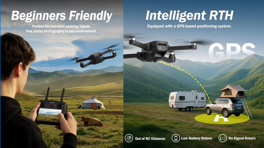
- Safe Return Home: If your drone loses its connection with the remote control or is running low on battery, GPS can step in and guide it safely back to where it took off.
- Limitations: GPS can set virtual boundaries, sort of like invisible fences, to keep your drone from wandering too far or going into places it shouldn’t.
Main Uses Of GPS Drones
Drones equipped with GPS can be put to work in many ways:
- Aerial Photography and Videography: GPS helps your drone stay steady in the sky, making it perfect for taking beautiful aerial shots, filming events, or capturing stunning landscapes.
- Inspection and Monitoring: Your drone can inspect things like power lines and pipelines safely and efficiently, thanks to GPS. It also makes it easier to spot problems and figure out what’s going on.
- Precision Farming: GPS-enabled drones are a big help in agriculture. They can gather data about crops and soil, which helps with things like precise fertilizing, controlled irrigation, and spotting crop issues early.
- Search and Rescue: Drones with GPS can cover large areas and send back real-time images. This speeds up search and rescue operations and improves the chances of finding missing people.
What Kind Of Signal Do Drones Use?
Drones mainly use the GPS signal, which is a radio signal sent out by satellites. Some drones can also tap into other systems like GLONASS, Galileo, or BeiDou for even better accuracy, especially in different parts of the world.
Where Is The GPS On A Drone?
You can think of the GPS in a drone like its internal GPS receiver. Sometimes it’s built into the drone’s body, and other times it’s connected via a GPS antenna. The important thing is that the GPS receiver has a clear view of the sky, so it can catch those signals from the satellites without any obstacles in the way.
In a nutshell, GPS is the drone’s guiding star, helping it perform various tasks accurately and safely. It’s like the drone’s own GPS superhero, ensuring it doesn’t get lost in the sky.
FAQs About GPS In Drones:
Q: Does the Drone DX-3 have a GPS sensor in it?
The Drone DX-3 does not typically come with a built-in GPS sensor. It’s a basic drone that relies on manual control rather than GPS for navigation.
Q: Does drone GPS work in the Philippines?
Yes, drone GPS technology works in the Philippines, just as it does in many other parts of the world. It can be used for precise navigation, photography, and various other applications.
Q: How can spoofed GPS signals be combated in drones?
Combating spoofed GPS signals in drones involves using anti-spoofing and anti-jamming technologies. These can help protect the drone’s GPS system from receiving false signals, ensuring its accurate and safe operation.
Q: How do we operate GPS in a drone?
Operating GPS in a drone is usually automatic. You simply activate the drone, and it uses GPS signals for positioning and navigation. Some drones may have specific settings or modes for GPS operation, so it’s important to consult your drone’s user manual for precise instructions.